Space of Struggle
Strauss 17, Jerusalem
2022
“Space of Struggle” examines Strauss 17 — in the Zikhron Moshe neighborhood — as a site where history, faith, and ideology accumulate and collide. The remnants of the sacred Muslim landscape — the Nabi Uksha Mosque, the Qamariya tomb, and ancient olive trees — coexist with the Histadrut building, Uksha Garden, and the planned light-rail station, creating a multilayered fabric shaped by simultaneous acts of erasure and preservation. The project reveals the socio-political discourse embedded in the language of preservation, in which stone façades act as envelopes of forgetting, maintaining an image of sanctity while the narratives behind them shift or disappear. The ground is understood as a living, charged archive — a tectonic body where time, material, and belief sink into one another. Two architectural actions guide the intervention: peeling and making-present. The Histadrut building takes on a new role as an open civic space connecting the sacred site, the garden, and the station, proposing a layered encounter between sacred and secular, past and present.
The Israeli City Studio, guided by Architect Ifat Finkelman , 3rd Year

Strauss 17 in Jerusalem is located within an urban landscape that embodies a long-standing religious and cultural struggle, reflecting the demographic transformation of the surrounding environment. Situated north of Jaffa Street, at the seam between the neighborhoods of Mea Shearim and Zikhron Moshe, the site contains two historical objects—the mosque and the turbah—which represent religious markers of a different way of life that once existed in the area. The structure that today defines Strauss 17 is the Histadrut Building, an institution that came to express a different ideology and a different narrative from those that shaped the neighborhood during those years.


The first settlements outside the walls of the Old City developed to the north and south of Jaffa Street and expanded over the years. Five of these early neighborhoods share a common edge with the site—Strauss 17. The center serves all the surrounding ultra-Orthodox neighborhoods and functions as a significant focal point, primarily through its western and eastern façades.


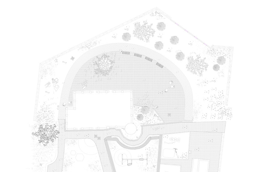
The remaining open space in the neighborhood is defined by three buildings that characterize the core of the site’s struggle and narrate its evolution. Over the years, the area absorbed the development of Jerusalem and accumulated a sequence of transformations—from the Qamariya Tomb, the Muslim burial structure, to the Nabi Uksha Mosque, and the demographic changes that reshaped the region. The site continued to accumulate layers of development: the Histadrut Building, Uksha Garden, the light-rail line, and municipal infrastructures.
All three buildings are designated for preservation, as are many others on the site. Yet preservation efforts focus mainly on the architectural envelope—the façades—while the original ideologies embodied in these structures remain unaddressed.
_edited.jpg)


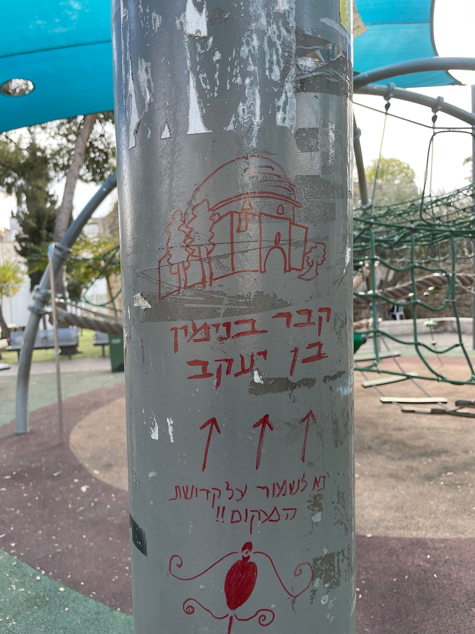
Qamariya Tomb

Qamariya Tomb
The Qamariya turbah was part of a network of Muslim tombs and sacred olive trees that marked the routes leading to the Old City. Members of the Qamariya family, killed in battles against the Crusaders, are buried there. Over time, this sacred landscape was reshaped to serve the narrative of the local ultra-Orthodox community; the area narrowed, became enclosed by the neighborhood’s buildings, and shifted from a natural ritual space to one that is neglected and planned.


Adjacent to the turbah, the former garbage area is transformed into a new entrance connecting Yeshayahu Street to the site, creating a pathway that links the different levels and reshapes the viewpoint toward the turbah, enhancing its visibility from the street. This intervention creates a gentle, almost ceremonial approach to the site, reopening the historical movement sequence and restoring the turbah to its role as a visible and accessible landmark within the urban landscape.
Add paragraph text. Click “Edit Text” to update the font, size and more. To change and reuse text themes, go to Site Styles.Add paragraph text. Click “Edit Text” to update the font, size and more. To change and reuse text themes, go to Site Styles.Add paragraph text. Click “Edit Text” to update the font, size and more. To change and reuse text themes, go to Site Styles.Add paragraph text. Click “Edit Text” to update the font, size and more. To change and reuse text themes, go to Site Styles.Add paragraph text. Click “Edit Text” to update the font, size and more. To change and reuse text themes, go to Site Styles.Add paragraph text.


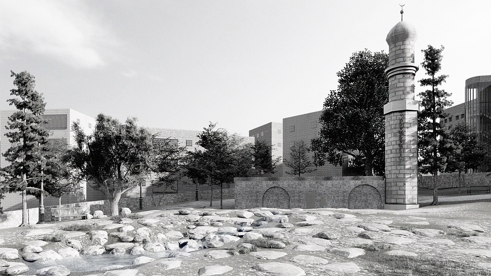
Nabi Uksha Mosque
Add paragraph text. Click “Edit Text” to update the font, size and more. To change and reuse text themes, go to Site Styles.Add paragraph text. Click “Edit Text” to update the font, size and more. To change and reuse text themes, go to Site Styles.Add paragraph text. Click “Edit Text” to update the font, size and more. To change and reuse text themes, go to Site Styles.

Nabi Uksha Mosque
The mosque, named after one of the Prophet Muhammad’s companions, was maintained by a Muslim family until 1948. Believed by some to hold the graves of Moses, Jesus, and Muhammad, it grew from the turbah into an active sacred site that shaped the surrounding landscape. With the construction of Zikhron Moshe, tensions over the holy places surfaced, and despite a posted warning to protect the site, the area between the mosque, the sacred trees, and the turbah was turned into a neighborhood playground.
The landscape was leveled, the Ottoman water cistern was sealed, and new buildings enclosed the site. The mosque was converted from a place of worship into a municipal storage space.
The northern plaza was preserved, while the southern one was demolished and replaced with Uksha Garden, which expanded over time, replacing the natural surroundings with asphalt and synthetic surfaces and eventually reaching the mosque’s entrance.


A minimal act of peeling the industrialized ground was carried out on the site, exposing the soil and creating a place of settlement similar to what once existed at its origin. In the southern plaza of the mosque, which had been erased as part of the renovation of Uksha Garden, archaeological remnants of an Ottoman-period water cistern and walls were uncovered. Following the removal of the rubber and asphalt, the ground was revealed, and the water cistern once again generates continuity between the turbah and the mosque.Historically, the cistern served as a shared resource for the surrounding communities, used for everyday purposes—a place that enabled encounter.

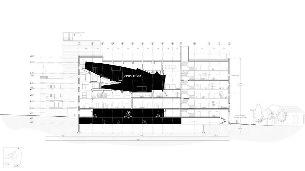
The Histadrut Building
The Histadrut Building introduces a new actor with a narrative distinct from what previously existed on the site. Mapai — the Workers’ Party of the Land of Israel and Israel’s ruling party until 1977 — promoted strong state involvement, social welfare, and agricultural support, and founded the Histadrut, the national workers’ organization and one of the country’s most influential institutions. Construction of the Histadrut Building in Jerusalem began again in 1953. Originally, the building contained administration offices and public facilities dedicated to workers’ welfare — including a cinema, a sports hall, a library, and a theater. Over time, this unified complex was fragmented: the Mitchell Cinema was divided into four floors for the Oritah Yeshiva, and the Hapoel Jerusalem basketball court was partially converted into classrooms for Hadassah College, using simple partitions that left the upper hall unusable.
Today, the Histadrut Building reflects the demographic transformation of the area. The Histadrut has been pushed into the northern wing, now occupying only 38% of the building.


May 1st, International Workers’ Day, once held a strong spatial presence in the area, characterized by processions along Strauss Street and flags displayed from the balconies of the Histadrut Building. With the demographic shift in the neighborhood, the nature of public practices changed, and gatherings and civic events in the space took on a different character — for example, the ceremony of bringing a new Torah scroll into the study hall of the Oritah Yeshiva.


The open space enclosed by the three buildings becomes the foundation for a new design strategy based on peeling and making-present—subtracting from the ground while simultaneously introducing new connections. These interventions fracture the site’s edges and open it to the city, transforming what was once a concealed and fragmented center into an active public space.


The Histadrut Building is reintegrated into the urban fabric through new entrances, the opening of basement levels, and the activation of the vertical range between –1 and +1, linking archaeological remains, the basketball hall, the light-rail station, and Uksha Garden. The formerly closed basement becomes a continuous circulation route connecting all levels, while Level –1—four meters below ground—becomes the building’s new main entrance.
Detaching the street level from the building allows natural light to penetrate the underground spaces, while new bridges connect the street to the viewing gallery of the hall. The relationship between the building and the city is redefined through exposure, openness, and the reintroduction of a lost topography, merging new infrastructure with the site’s historical landscape to create a single, accessible urban continuum.


